Beavers and Bays
One of the intriguing aspects of the Carolina Bays is
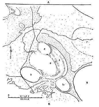
that they frequently overlap one another. Prouty reasoned
that bays impinging on other bays were the result of multiple,
serial, impacts with the last in the sequence retaining the
common Carolina Bay form. A problem with this method of
creating Carolina Bays is that the rim height of ostensibly later
formed bays is generally about the same height as the rim of
those bays that were impinged upon. It is difficult to find
a convincing way for multiple impacts to produce a bay within a
bay with a rim height that matches the bay that contains
it. The gloss over to this hard to account for property is
that the bays are so shallow that virtually any rim height would
be enough to bring later formed bays up to about the level of the
earlier formed bays. This is a weak explanation and also
points to another problem with a direct impact model—the
shallowness of the features.
If we examine how beavers go about constructing their
semi-aquatic environment however, the relationship of bays to one
another becomes less of a problem to explain. In pursuit of
fresh trees for food and construction, beavers build canals as
well as multiple dams along these water paths to function as
locks—they do not like to drag logs for long
distances. Also, as the family or colony expands in the
number of reproducing couples, new ponds, often nearby, are
produced.
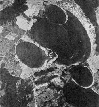
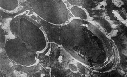
Below are a few examples of how beavers
alter their immediate environment.
These images are from a
wonderful book published in 1914, The
Romance of the Beaver, by A. Radclyffe Dugmore. One
can see by comparing the aerial photos and Prouty’s drawing
of clustered Carolina Bays how direct the relationship seems
between beaver pond arrangement and Carolina Bay
occurrence. It is also obvious that the beaver ponds would
not all have the same surface area to depth relationship and so
would not flash into steam
simultaneously. This would allow a sequence of bay
formation as Prouty proposed in the numbered drawing below.
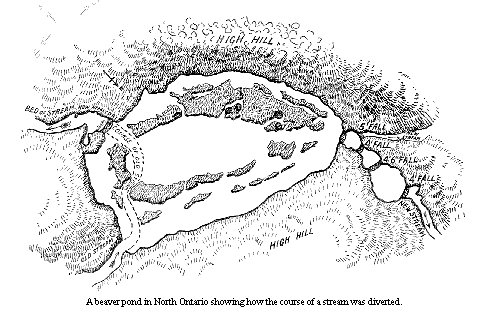
bobk
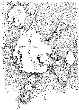
|
The streams shown in dotted line were dammed at A and
B; as the water rose it formed two other outlets, a and
D. At these points additional dams were put. Later,
to reinforce the principal structure, supporting or
subsidiary dams, E, F, G and H, were built. On the
island, I, formed by the rising water was the first
lodge. On the west side arc the roads, J, to the
birch and maple trees. To the north-east is a
canal, E, built in order that the beavers might have
access to the groves of aspens, which was situated on
rising ground and necessitated making the canal with
three dams to hold the water at the different
levels. Toward the end of the east wing of the
canal is B straight line, L, indicating the small
aqueduct or ditch cut by the beavers in order that water
might be diverted from the streamlet to ensure an ample
supply for the canal. Other small canals, M, arc for the
purpose of making short cuts when transporting food
supplies. The upper pond, N, was made by the second
pair of beavers, who had been driven from their own home
by fire. The dam forming this pond is O, with
subsidiaries P, Q. The lodge, R, on a point of land
which has been formed into an island by cutting a
ditch. The second lodge was built by one of the
young from the first lodge. A.R. Dugmore,
1914
|
Click for an
image of a C-Bay size beaver dam in the Lake Superior area.
Home,
Blowing Steam, Fire and Water, C-Bay
Menu